[background – submitted version]
Background
|
Figure 1. A typical Santa Fe Building[1] |
With a population of 70,000 primarily Hispanic, Anglo and Native American people, Santa Fe, which means Holy Faith in Spanish, is New Mexico’s fourth largest city behind Albuquerque, Las Cruces and Rio Rancho. Situated at 7,000 feet in the foothills of the southern Rocky Mountains, it was founded between 1607 and 1610, making it the second oldest city as well as the highest and oldest capital in the U.S.[2]
The Spanish laid out the city according to the “Laws of the Indies”, town planning rules and ordinances which had been established in 1573 by King Philip II. The fundamental principle was that the town be laid out around a central plaza. An important style implemented in planning the city was the radiating grid of streets centering from the central Plaza. Many were narrow and included small alley-ways, but each gradually merged into the more casual byways of the agricultural perimeter area.[3]
Today, Santa Fe is recognized as one of the most intriguing urban environments in the nation, due largely to the city’s preservation of historic buildings and a modern zoning code, passed in 1958, that mandates the city’s distinctive Spanish-Pueblo style of architecture, based on the adobe (mud and straw) and wood construction of the past. Also preserved are the traditions of the city’s rich cultural heritage which helps make Santa Fe one of the country’s most diverse and fascinating destinations.[4]
2.1 Santa Fe Foundation: Trails and Trading
Santa Fe is one of the most historic cities in the United States, and often referred to as the oldest capital of the nation. However, despite its significant historical importance, little is known about the cities’ beginning. The reason why the city became the capital of New Mexico appears to be strongly related to its protective and stable location.[5]
Before Santa Fe, the capital of New Mexico in the early 1600s was Villa de San Gabriel, located on the west bank of the Rio Grande, opposite San Juan Pueblo. This arrangement was carried out by New Mexico’s first governor and founder Juan de Onate. However, in 1608, Onate realized the lack of defensibility in Villa de San Gabriel, and the inconvenience of the constant conflict between his followers and the local Pueblo Indians. Therefore, he immediately proposed to Mexico City a plan of relocating his settlers in the Valley of Santa Fe River. This vicinity was said to have been more defensible, and more importantly, not inhabited by any Pueblo Indians; actually, people from San Gabriel had already been migrating to the valley as early as 1607. Another reason for this transfer would be the scarcity of farmlands in the old capital.[6]
This plan was not executed until the arrival of New Mexico’s second governor, Don Pedro de Peralta, in January 1610. Entrusted by Onate with his plan to move the provincial capital to a better site, Peralta completed the relocation of Onate’s people from San Gabriel to the Valley of Santa Fe River in late 1610. Since the place was named Santa Fe by the pre-existing settlement, Peralta left the name unchanged. This name also indicates the defensive location of the place through an analogy with another town named Santa Fe in Spain. That town was built as a walled military camp outside the last Moorish stronghold of Granada. Its design was based on the Roman grid plan and proved so successful that it became the model for towns in cities built throughout the Spanish Empire. Therefore, it is reasonable to assume that Peralta highly appreciated the valley as a safe land by keeping its name as Santa Fe[7].
|
Figure 2. Architecture of Santa Fe during its foundation[8] |
2.1.1 Significance of Santa Fe Trade Routes
The Santa Fe Trail (aka, Santa Fe Road) was an ancient passageway used regularly after 1821 by merchant-traders from Missouri who took manufactured goods to Santa Fe to exchange for furs and other items available there. Mexican traders also provided caravans going to western Missouri in this international trade.[9]
|
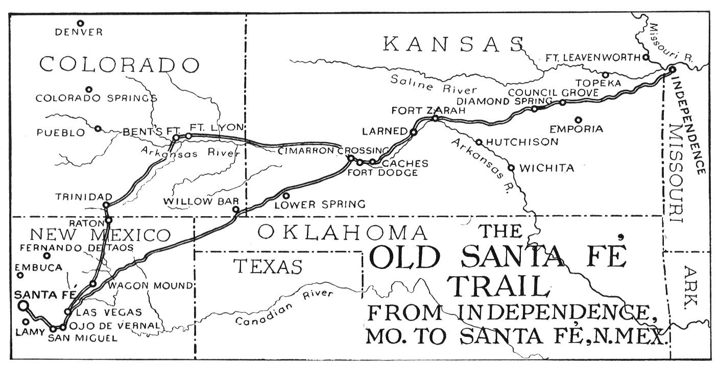
Figure 3. Santa Fe Trail[10] |
In western Kansas a Santa Fe-bound caravan had the choice of two routes: The Mountain Route (Long Route) of the Santa Fe Trail was the 230 miles of unprotected campsites between Fort Larned and Fort Lyon in Colorado. It followed the Arkansas River into Colorado before turning south. The Jornada Route was the water-less (dry or desert route) stretch cutting southwest at Cimarron Crossing and other Arkansas River crossings. This route saved ten days and would carry 75 percent of all future trade.[11]
|
Figure 4. El Camino Trail[12] |
Apart from the Santa Fe Trail, the history of trading in this city also depended on the El Camino Real. In 1598, Don Juan de Onate led 500 colonists through remote and unfamiliar country, encountering people with vastly different languages and cultures, not knowing what awaited them at the end of the journey. Onate followed what became known as El Camino Real, “the royal road”, which up until then only reached the frontiers of northern Mexico. Onate’s journey was the beginning of almost three centuries of travel and commerce in New Mexico on the Camino.[13]
To elaborate, approximately 1,500 miles long, the trail started in México City and ended in the Spanish town of Santa Fe. During its first two centuries El Camino Real brought settlers, goods and information to the province. It carried crops, livestock and crafts to the markets of greater Mexico. When Mexico gained its independence from Spain in 1821, its northern frontier was opened to foreign trade. New Mexico soon became the destination of U.S. and French Canadian traders carrying goods from Missouri on the newly blazed Santa Fe Trail. Once El Camino Real connected with the Santa Fe Trail, Santa Fe became the important link between the growing U.S. economy and the long-established Mexican economy. For 60 years El Camino Real served as the principal route for both Mexican and U.S. traders traveling into the interior of Mexico.[14]
Presently, renamed as Agua Fria Street, it leads into the heart of the modern City of Santa Fe. Sculptures in Frenchy’s Field Park (Agua Fria and Osage Avenue) and Santa Fe River State Park (Agua Fria and Guadalupe Street) commemorate the centuries of travel through Santa Fe on El Camino Real.
2.1.2 New Role of Trails
Many communities grew along the Santa Fe Trail in northeastern New Mexico in order to provide goods, services, food, shelter and water to the many wagon trains passing through. As the wagon trains gave way to the railroad, mining and cattle became important to life on the trail. Today, cattle remain, but traveling the highways and byways by automobiles is now the main mode of transportation, and art, recreation and culture are major attractions.[15] El Camino Real, first traveled in 1598, provided news, supplies, and travel to the first capital of the New World[16]. In modern days, the major use of both the Santa Fe and El Camino Real trails are that of tourist attractions. Though the trail routes themselves still exist and can be traveled by foot, bike, or even covered wagon, they are most often traveled by vehicles that allow passengers to stop at certain important sightseeing points along the trails. The end of El Camino Real remains at St. Francis Drive in Santa Fe, NM, one of the most frequently traveled roads in the city. Although the trails are now tourist attractions, they still contribute to the overall structure of Santa Fe.
2.1.3 Emergence of the Railroad
|
Figure 5 The Santa Fe Rail Runner[17] |
On February 9, 1880, the Atchison, Topeka and Santa Fe Railway Company pulled its first train into the Santa Fe, New Mexico depot, its arrival celebrated by colorful speeches and a grand parade. Artists hired by the rail line drew and photographed images of Santa Fe to entice faraway Easterners to come see the West. Local Native American and Hispanic arts and crafts were created to market to rail travelers. Building materials brought in on the rail, such as galvanized tin and bricks, added metal roofs and Victorian brick buildings to the pueblo style architecture of Santa Fe. New neighborhoods were created around the Railyard to house the workers and their families involved in the new rail economy. Santa Fe’s Railyard became a center of activity, its station a greeting place for visiting politicians and celebrities as well as the sentimental point of departure. The site remained a central hub until rail transportation began to be eclipsed after World War Two by the interstate highway system and the airlines.[18] The convenience of communicating with the outside after this particular emergence of the railroad has moved Santa Fe into a new era of growing as an urban area.
2.2 Urban Growth after the Railroad
In the city of Santa Fe, approximately 5-6 acres are developed for every 100,000 square feet of commercial floor area constructed[19]. As a result, 135-162 acres of land have been commercially developed in the city since 2000. Annual growth averages for the city of Santa Fe include approximately 84,000 square feet of new office space (31%), 143,000 square feet of new retail-related development (53%), and 27,000 square feet of new industrial/ warehouse development (10%). Schools and churches, central components of the community, only comprise the remaining 6%. As is evidenced by the percentage devoted to growth of business and retail space, Santa Fe is a city that is expanding commercially while compromising the traditionally close knit community. This is characteristic of sprawl in general.
One example of urban sprawl currently taking hold in Santa Fe is the average amount of time it takes to commute to the workplace, which is 17.5 minutes. Of workers aged 16 years and older, 72.4% commuted to work by driving alone, while an additional 13.3% took advantage of a carpool system. As noted before, the evidence of vehicular dependence, as well as distance to travel to work, are issues that redevelopment hopes to eliminate. A combined 5.6% of the employed population either walked or used public transportation to get to their workplace, something redevelopment also hopes to reverse.[20]
|
Figure 6. Population Growth[21] |
2.2.1 A Growing Population
In 2000, the population in the City of Santa Fe was 62,203, and it was estimated that it would grow to 72,056 in 2006 with a growth rate of 14.5%. At that time, the percentage of people who were 65 years old and over was 13.9%. However, Santa Fe’s population is aging with a rapidly shrinking population of individuals under 45 years old. This aging population will lead to a disadvantage when attempting to attract potential company recruits that seek young, innovative individuals. People at a young age might also be interested in entrepreneurship, and more likely to start their own businesses. But the growing base of seniors reverses the character of the city and results in a negative impact on the city finances.[22]
2.2.2 Road Development to Satisfy Urban Growth
|
Figure 7. Interstate 25 alongside the RailRunner, connecting Albuquerque and Santa Fe[23] |
The history of many cities and towns can also be traced by the origin and development of urban thoroughfares. That’s certainly the case with Santa Fe, where many widely used existing roads were once frequently traveled trade routes. Additionally, the cultural intersection of Native American, Spanish, and Anglo-Saxon traditions provided the basis for the diverse naming and development of the streets of Santa Fe. The honor of being the oldest street in Santa Fe probably belongs to what is now San Francisco Street; originally it bore the name Calle Real and was in effect the tag end of El Camino Real, the trade route that began in Mexico City. The old Camino Real (modern day Agua Fria Street) crossed the Santa Fe River and narrowed to become the Calle Real leading to the Santa Fe Plaza. By the early 20th Century Anglos had introduced Agua Fria Street, the name taken from the small community just south of Santa Fe. St. Francis Drive is to this day a portion of the old El Camino Real trail. A movement got started about 20 years ago to return Agua Fria Street to its historical first name, El Camino Real, but residents and businessmen resisted the change, and Agua Fria remains.[24] The development of the road system in Santa Fe is closely tied to the population explosion that the southwest United States has experienced in the last 50 years.
2.3 The Development of Saint Michael’s Drive
Originally designed to serve as a connecting suburban “truck by-pass” highway around what was then the southern edge of Santa Fe, St. Michael’s Drive has since become a commercial corridor at the center of Santa Fe’s Urban Area containing nearly 90,000 residents. St. Michael’s Drive is one of the city’s busiest streets and has become essential to the urban fabric of the city.[25] St. Michael’s Drive has seven lanes of traffic and it handles approximately 25,000-30,000 vehicles per day[26].
St. Michael’s was first built in the late 1950s connecting the two legs of then-State Highway 85 heading to Albuquerque and Las Vegas, respectively. St. Michael’s Drive predates construction of St. Francis Drive, Paseo de Peralta and Interstate 25. An urban interchange was added as St. Francis Drive bridged St. Michael’s Drive on its way south to connect with the newly built I-25. Though St. Michaels Drive has become a hub of travel, it has been identified in public forums as lacking a redeeming urban form or aesthetic. St. Michael’s Drive has the potential to be transformed into a truly great pedestrian / shopping / mixed use street. To encourage that change, buildings must be allowed, even required, to be built near the street so that storefronts are easily accessed by pedestrians, bicyclists and bus riders, not just cars.[27]
2.3.1 Current Issues
|
Figure 8. A typical portion of St. Michael’s Drive with curb cuts[28] |
Certain requirements of redevelopment are: preservation of historic character, improvement of the retail framework of the city, encouragement of local-serving housing downtown, and promotion of the unique artistic culture of the city.
First, apart from the heavy traffic mentioned above, St. Michael’s Drive does not favor pedestrian particularly because of the large number of curb cuts that one may encounter along the street. These curb cuts are formed at the intersection of the drive with other roads or serve as a tunnel leading drivers into the local strip malls. They pose serious safety problem for pedestrians each time a car cross their paths through a curb cut. For example, on only a small portion of St. Michael’s Drive, there are six curb cuts preventing pedestrian from having an uninterrupted walk. See Figure 8.
Another concern regarding St. Michael’s Drive is its shape, dictated by the strip malls around, as a sprawl of single-use building. A great example of St. Michael’s Drive suburban sprawl is St. Michael’s village west. Saint Michael’s Village West Shopping Center is located in the geographic center of the city of Santa Fe at the intersection of Saint Michael’s Drive and Llano Street, between Cerrillos Road and Saint Francis Drive. As seen in Figure 9, there is a large parking lot adjacent to St. Michael’s that is an eyesore and does not fit in with the city’s redevelopment goals. St. Michaels Village West serves the local community as a plaza that houses many different retail stores, similar to many American strip malls.
Figure 9. Village West as a sprawl[29]
Last but not least, regarding the consistency of St. Michael’s Drive with the character of the cities, certain requirements of redevelopment emerged, namely the preservation of historic character, improvement of the retail framework, and promotion of the unique artistic culture of the city in the local area[30]. Planners hope for mixed-use commercial buildings and medium to high density residential buildings alongside traffic calmed road and aesthetically pleasing green public spaces[31]
2.3.2 St. Michael’s Dr. Charrette Trends
To paint a better picture of what St. Michael’s Drive could look like in the future, the City of Santa Fe asked seven urban designers to create their vision of what St. Michael’s Drive could be including the roadway design and land use designs/options for the adjoining areas. Out of this urban design charrette, or effort to catalyze real architectural redevelopment, several common themes were drawn. St. Michael’s will be multi-modal with transit connections between the Santa Fe Trails bus system and a local train that extends through the heart of this district. As with so many higher volume roadways built in the 1950s and 1960s, St. Michael’s Drive has little redeeming value for pedestrians or bicyclists; it was built almost entirely with the automobile in mind. The roadway width, alone, makes it imposing for pedestrians or wheelchairs to cross St. Michael’s anywhere along its length. Transforming this roadway into a great boulevard that is beautiful, pedestrian-friendly, bicycle-friendly, and transit-oriented, while serving well-designed urban places along its length, is the goal of the “Santa Fe Boulevards” program.
In order to achieve the goal of the program, there are several themes that form the larger redevelopment goal. For instance, medians should be widened and re-landscaped to separate traffic better as well as to provide scenic boundaries. Sidewalks must be widened and driving lanes either decreased in number or narrowed in width to promote pedestrian friendliness. The city of Santa Fe has the right to do whatever it pleases with public areas such as streets and sidewalks, and the implementation of such ideas is likely to be easier than those of private development. With respect to private development along St Michaels, restrictions are necessary to ensure buildings are located next to the street with parking in the rear, essentially the opposite of most common modern strip malls. Possibly the biggest issue concerning private redevelopment is the creation of multi-story, mixed-use buildings. Also, large windows and easier access to the street for tenants of privately owned buildings should be incorporated. In a city such as Santa Fe, where the “adobe theme park” has long been the norm, encouragement of high density as well as tall structures is something not previously considered.[32]
[1] http://santafe.org/Visiting_Santa_Fe/Plan_Your_Trip/History/index.html
[2] Santa Fe, NM Convention and Visitors Bureau. About Santa Fe. 2010 [cited 03/18
2010].
http://santafe.org/Visiting_Santa_Fe/About_Santa_Fe/index.html.
[3] Wikipedia. Santa Fe, New Mexico. 2009[cited 03/21 2010]
http://en.wikipedia.org/wiki/Santa_fe,_nm.html.
[4] Santa Fe, NM Convention and Visitors Bureau. About Santa Fe. 2010 [cited 03/18
2010].
http://santafe.org/Visiting_Santa_Fe/About_Santa_Fe/index.html.
[5] Simmons, Marc. Origins of Santa Fe. Accessed 3/18/2010. Copyright © 2000-2007 Santa Fe
Always Online, Inc.
http://www.sfaol.com/history/origins.html
[6] Simmons, Marc. Origins of Santa Fe. Accessed 3/18/2010. Copyright © 2000-2007 Santa Fe
Always Online, Inc.
http://www.sfaol.com/history/origins.html
[7] Simmons, Marc. Origins of Santa Fe. Accessed 3/18/2010. Copyright © 2000-2007 Santa Fe
Always Online, Inc.
http://www.sfaol.com/history/origins.html
[8] http://www.gallagherstravels.com/States/NM/trio/
[9] Virtual Library. Santa Fe Trail: William Becknell. 2009 [cited 03/21 2010].
http://www.vlib.us/old_west/trails/sfthist.html.
[10] http://www.socialstudiesforkids.com/graphics/santafetrailmaplarge.jpg
[11] Virtual Library. Santa Fe Trail: William Becknell. 2009 [cited 03/21 2010].
http://www.vlib.us/old_west/trails/sfthist.html.
[12] http://www.las-cruces.org/public-
services/museums/history_exhibit/Images/AlongCamino/caminoMapLg.gif
[13] Frantz, Laurie. El camino real national scenic byway. 2009 [cited 03/20 2010]. http://www.newmexico.org/explore/scenic_byways/camino_real.php.
[14]Ellick, Carol J. “The Grand Adventure! El Camino Real de Tierra Adentro; the Royal Road from
Mexico City to Santa Fe”. SRI Foundation Rio Rancho, NM, 2003.
http://www.srifoundation.org/library.html
[15] Magoffin, Susan Shelby and Lamar, Howard R. 1982. Down the Santa Fe Trail and Into Mexico:
The Diary of Susan
Shelby Magoffin, 1846-1847. Edited by Drumm, Stella Madeleine.
ISBN 9780803281165
[16] U.S Department of Transportation: National Scenic Byways Program. El camino real overview.
2009
[cited March 18 2010].
http://www.byways.org/explore/byways/2065/stories/46941.
[17] http://www.lightrailnow.org/images02/abq-rpr-Santa-Fe-waiting-pax-20090320_Waldy-
Gallery.jpg
[18]Santa Fe Railyard. Santa Fe Railyard-A History 2009[cited 03/20 2010]
http://railyardsantafe.com/index.php?page=history
[19] The City of Santa Fe Government. Santa Fe Trends 2010. Accessed 3/18/2010
http://www.santafenm.gov/DocumentView.aspx?DID=5493
[20] U.S Census Bureau. Santa Fe, NM Profile of General Demographic Characteristics. 2000 [cited
3/10/2010 2010].
[21] http://www.censusscope.org/us/m7490/chart_popl.html
[22] The City of Santa Fe Government. Cultivating Santa Fe’s Future Economy: Target Industry
Report.[cited February 22, 2010]
http://www.santafenm.gov/DocumentView.aspx?DID=1291
[23] http://3.bp.blogspot.com/_DrTowL4cK6U/Sds6xfuATzI/AAAAAAAAEpU/-
RdcVEcG94A/s320/railrunner-median-2.jpg
[24] Simmons, Marc. Santa fe’s street names. 2007 [cited March 18 2010].
http://www.sfaol.com/history/street.html.
[25] Liming, Reed. 2010. Boulevard redevelopment project: St. michael’s drive existing conditions.
03/02/2010.
[26] The City of Santa Fe Government. Santa Fe Trends 2010. Accessed 3/18/2010
http://www.santafenm.gov/DocumentView.aspx?DID=5493
[27] Liming, Reed. 2010. Boulevard redevelopment project: St. michael’s drive existing conditions.
03/02/2010.
[28] GIS Layer of the City
[29] http://www.thomasprop.com/retailspace.html
[30] The City of Santa Fe Government. Downtown Vision Plan. Accessed 3/18/2010
http://www.santafenm.gov/DocumentView.aspx?DID=1408
[31] The City of Santa Fe Government. Downtown Vision Plan. Accessed 3/18/2010
http://www.santafenm.gov/DocumentView.aspx?DID=1408
[32] Liming, Reed. 2010. Boulevard redevelopment project: St. michael’s drive existing conditions.
03/02/2010.


No comments yet
Jump to comment form | comment rss [?] | trackback uri [?]